Please note: this page is part of our Draft Local Plan and has been superseded by our Local Plan
What is the Draft Local Plan?
The Local Plan sets out how Central Bedfordshire will develop over the next 20 years. It outlines the strategy for ensuring the growth that we need is delivered in the right place, and is of the right character and quality. It also ensures that growth is delivered with the supporting roads, schools and services such as health, as well as retail, leisure and community facilities.
The
for Central Bedfordshire was endorsed for publication by the Executive Committee on 20 June. The Draft Local Plan was available for public consultation from 4 July for an eight-week period, until 29 August 2017. We are now processing all of the feedback from the consultation to inform the next iteration of the Local Plan (pre-submission plan) for consultation from 10 January – 21 February 2018.
Why the Local Plan is important?
Our prime location and excellent connectivity means that we have high growth pressures and this is the reason we need to plan for it. We need more homes and in particular, homes that you and your families can afford to buy and to rent. It means that we need to continue to create more jobs to grow the local economy and that we need to keep improving our transport networks. It also means that we need to protect and enhance what you love about where you live.
Producing a Local Plan is a priority for us for a number of reasons. The government is clear that local authorities are expected to have up to date plans in place to guide development within their area to plan for the infrastructure, homes and jobs that our residents need.
Failure to have an up to date plan would risk government intervention and a resulting loss of control of the process. Having an up-to-date plan in place also means that we retain control over where development should be located rather than it being delivered in an ad hoc way as a result of speculative development, sometimes without sufficient benefit to local communities.
How we’ve been developing our Local Plan
The Plan has been informed by around 15 new evidence studies. These look at issues such as population, housing, employment, retail and flooding.
We’ve also considered existing, potential and new transport infrastructure e.g. roads and railways, so that growth and transport infrastructure go hand in hand.
We’ve developed the Draft Local Plan with residents’ input – through Community Planning events and our Shaping Central Bedfordshire consultation and we will continue this engagement with you because we want to make sure we get this right.
Listening to the community
From the consultations and community engagement events, we know that local communities want us to:
- keep the character of Central Bedfordshire
- limit the impact on the countryside
- plan for homes for the older generation and affordable homes
- plan for local jobs and services
- make sure our roads can cope
- build near to existing roads and infrastructure
- use brownfield sites
What the Draft Local Plan proposes
Homes: 20,000 - 30,000
The number of homes we need to plan for is calculated using a standard national approach. However, we need to be flexible and therefore we’re planning for a range of between 20,000-30,000 new homes. Further work will be undertaken to establish an exact amount when we produce the next version of the Plan in 2018. This is in addition to the 23,000 homes that are already allocated or have planning permission.
The options put forward in the draft plan to deliver this housing growth are through:
- creating new attractive villages
- creating a new market town
- expanding existing towns; and
- growth in existing villages, but only where services can support it.
Some of this development will be dependent on improvements to our transport networks, plus the development of critical new infrastructure, like the proposed East-West Railway.
The plan includes a range of different homes to rent and buy with a mixture of sizes including family homes, two bedroom homes, apartments and bungalows. And, to help people get on the housing ladder, this will include 30% to be provided as lower cost options such as affordable rent and shared ownership.
The options for where this growth is proposed is shown on the map.
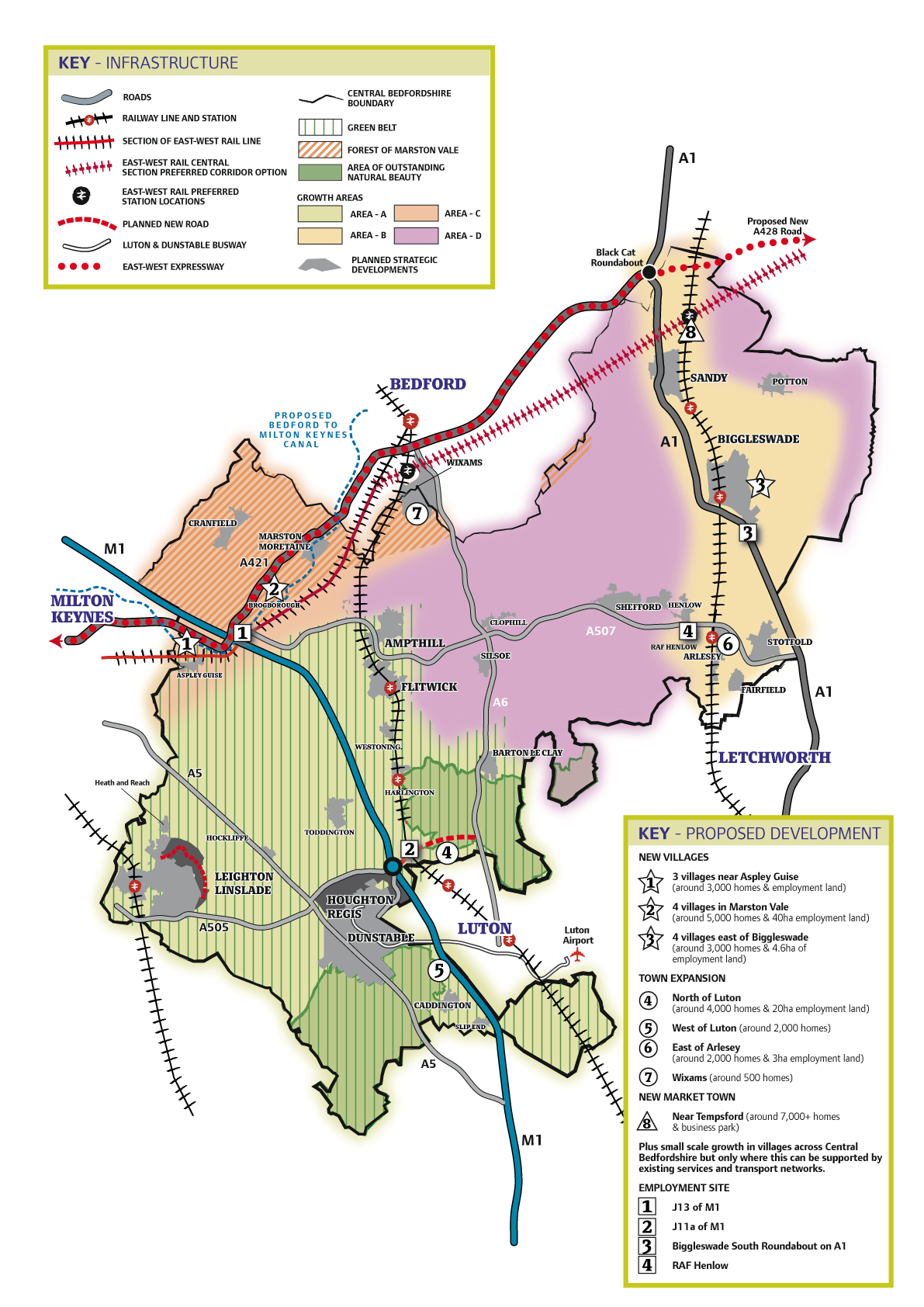
Jobs: 24,000 - 30,000
A range of new jobs would be delivered through existing sites and the proposed growth locations. Additionally, the plan proposes the following key employment sites at strategic locations close to the M1 and A1:
- J11a of M1 motorway
- J13 of M1 motorway
- Biggleswade South Roundabout on the A1
- RAF Henlow
These employment sites are also shown on the map.
Transport and services
We are planning for new infrastructure such as roads, schools, shops, leisure, community facilities and open space.
Sometimes infrastructure is put in place before housing is developed (for example, major link roads and schools have been developed to support future growth). At other times infrastructure follows development but they support each other, so we need to plan for both.
Transport
Existing and potential new roads and rail have already informed the draft plan, such as the M1-A6 link road and the Ridgmont Station upgrade.
Others are key to development in the areas we have proposed, such as the proposed East-West Railway and the Oxford to Cambridge Expressway. We are also lobbying government for improvements to the A1 and A421 to support this growth too.
Services
Small developments in and around villages will only happen where this can be supported by existing services or where the development will enhance these services and there is good accessibility.
Larger developments include requirements for road improvements, new shops, community facilities, leisure facilities, schools and health and care hubs.
Some of the larger developments are dependent on critical road and/or rail improvements to support them.
Countryside
We know how important the countryside and rural character of Central Bedfordshire is. Whilst we recognise that the number of homes we’re required to build is significant, in total these homes, together with those that already have planning permission, would equate to new development on only 4% of Central Bedfordshire land.
88% of Central Bedfordshire is countryside and 84% of it still would be countryside if the maximum number of homes that are proposed and planned are delivered.
Two of the options proposed in the plan use brownfield land (land that has previously been developed) and we’re seeking to use as much of this as we can. Unfortunately supply of brownfield land in Central Bedfordshire is very limited and there isn’t enough to deliver all of the growth that we require.
The draft plan proposes to increase public access to the countryside by creating more rights of way and country parks as well as play parks and open spaces within the proposed developments.
The plan includes protecting the Greensand Ridge, the Forest of Marston Vale, the Ivel Valley and the Chilterns areas of outstanding natural beauty (AONB), enhancing where possible and increasing access.
Planting, landscaping and creating green space between developments and existing areas of natural beauty will limit the impact of development on these important areas.
We will use green open space to prevent existing settlements merging, keeping their identity and the rural character of the area.